Bonny Doon and Ben Lomond Mountain
(Or: If Bonny Doon's not in them, where are the Santa Cruz Mountains?)
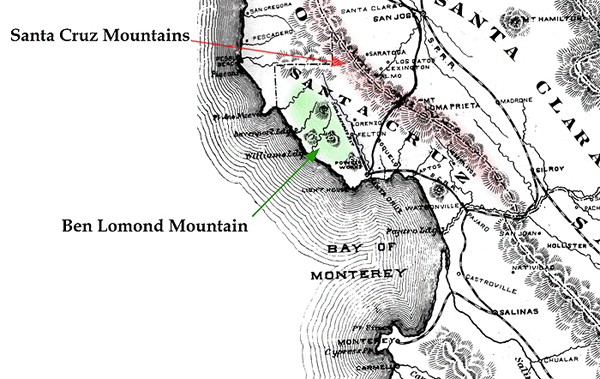
Ben Lomond Mountain
(shaded green, above) is the name for the
stretch of coastal
hills between the
San Lorenzo Valley and the ocean.
Eagle Rock, Lone
Star Peak
and Bald Mountain are the three
prominences on Ben Lomond Mountain that are evident in this venerable
map.
The Santa Cruz Mountains
(tinted red) are found east of the San Lorenzo valley
and follow the
border
between Santa Clara County and Santa Cruz County.
They're designated
as such on this map (and
most others) though the words are difficult to read here.
Loma Prieta, Mt.
Bache and Mt. Umanhum are all in the Santa Cruz Mountains.
The San Andreas Fault, the operative border between the North American
Plate and the Pacific Plate
to the west, runs along the Santa Cruz Mountains. The epicenter of the
1989 quake was located near Loma Prieta.
this time, Pacific Mills was a logging town on the San Lorenzo, which was re-named Ben Lomond in 1887, after the mountain.
Back to Bonny Doon history here.
Please find and read:
Santa Cruz County Place Names - A Geographical Dictionary
by Donald Thomas Clark
Published by the Santa Cruz Historical Society
ISBN 0-940283-01-8