
|
Rules for Non-Conforming Structures County Planning Director Kathy Previsich Coastal Watershed Protection Greg Pepping, Executive Director Coastal Watershed Council September 14, 2011 RBDA Meeting, 7:30 p.m. Bonny Doon School Multipurpose Room Ice Cream Grade & Pine Flat Road |
||
Two thought provoking topics at the September 14th RBDA meeting. Tell County Planning your thoughts on non-conforming structures As we reported in the last Highlander, County Planning has been working on revising their regulations on non-conforming structures and uses. Your board was able to take part in the focus group on Environment and Land Use. The group brought the concerns that we spoke of in the prior article to Director Kathy Previsich and 5 Planners, including Annie Murphy, who is leading the revision drafting. While many perspectives were offered and much of what we heard from Planning made good sense, we felt that the Bonny Doon community at large should have an opportunity to comment. We are happy to report that Director Previsich will be joining us at our Sept. 14 meeting to summarize the latest proposal draft, answer questions, and accept suggestions. The draft, which will soon be available on the County Planning website, sccoplanning.com, goes to the Board of Supervisors Sept. 20. We urge you to review the proposal and help us Keep Bonny Doon Rural by bringing your questions and comments in September. Stewarding and Monitoring Coastal Watersheds Since 1995, the Coastal Watershed Council, coastal-watershed.org, has been working to preserve and protect coastal watersheds through community stewardship, education and monitoring. We are pleased to have Executive Director Greg Pepping joining us at our September Meeting. The Council works with individual homeowners, renters, and small business owners on stewardship of our watersheds by providing guidance on reducing the quantity and improving the quality of water runoff from their properties. Among their educational events is the upcoming annual First Flush, a volunteer community effort to sample local watersheds during the first significant rain of the season, to see what pollutants have accumulated during the summer and will be entering the Monterey Bay National Marine Sanctuary. The Council monitors over 70 miles of streams in 8 watersheds for non-point pollution and salmonid habitat quality, including Laguna, Liddell, Molino, and Scott creeks flowing from Bonny Doon. Please join us Sept. 14 to learn how the Coastal Watershed Council is helping us Keep Bonny Doon Natural. Coast Dairies Diary In the beginning… Since the early 1900s the land known as the Coast Dairies property had been owned by a Swiss family. The family, which formed the Coast Dairies & Land Company, operated dairies on the property until the 1920s. In 1995 a Nevada development company acquired a stock option to purchase the corporation and its only asset, the Coast Dairies property, thus threatening the land with development. In 1997 the developers were poised to divide the land into as many as 139 luxury residential lots, which would destroy the property’s scenic splendor and its valuable agricultural lands. October 26, 1998, Coast Dairies Sale Finalized Save the Redwoods League closed its purchase of the Coast Dairies & Land property on Oct. 26, 1998 for a reported price of $40 million. It was paid for with donations by the Packard Foundation, the California Coastal Conservancy, The Nature Conservancy, other locally funded Land Trust donations and some State funds. The 7,500-acre property stretches along the coast for 5 miles between Laguna and Scott creeks. It includes beaches, agricultural lands, and mountain forests. The purchase ended threats of commercial development of the land. In recent years a Nevada development company holding an option made several attempts to develop the property just north of Santa Cruz. This threat became more pointed in 1997, when the developers were poised to split the land into as many as 139 lots through a non-public process. The plan was to begin to sell the lots for development of luxury homes. With the purchase, ownership rights were passed to TPL, whose responsibility it was to create a long-term property management plan which would be predicated on protection of the land from further development or environmental degradation. Public access to the property’s beaches would continue, but public access to the uplands would be deferred until a management plan was in place. A broad group of federal, state, and local interests, and the public, were invited to participate in the creation of the management plan. The William and Flora Hewlett Foundation and the Coastal Conservancy provided funds in support of creating the plan. Development of these analyses and documents was needed to comply with the requirements of the California Environmental Quality Act and the National Environmental Policy Act. October 1999 It became clear that TPL intended to turn the property over to the BLM and the California Department of Parks and Recreation. Before this could happen, however, it seemed that the yet-to-be-completed management plan would determine how BLM and CDP would be able to use the land. TPL formed a Citizens Advisory Group to provide input in the development of the management plan. Its first meeting was in September 1999. The RBDA was asked to participate in this group. Other groups participating on the task force were environmental organizations ranging from the California Native Plant Society to the Surfrider Foundation, Friends of the North Coast, farmers, Big Creek Lumber and RMC (the Davenport cement plant owner at the time), and federal, state and local government agencies and schools. The plan was to develop, with the task force’s input, by TPL and a Steering Committee consisting of STRL, the Land Trust of Santa Cruz County, the State Coastal Conservancy, Supervisor Mardi Wormhoudt’s office, BLM and CDP. The first step was to assess the property's resources, existing leases and historical uses, then identify areas that need to be protected or restored and those that could be used for recreational, agricultural and other activities. Then alternative management options were to be developed and analyzed and the final plan selected. It was unknown how long the process would take, but expectations at the time were no more than a couple of years. Winter, 1999 Responding to pressure from mountain bikers, surfers and other groups who felt left out of the advisory group on the Coast Dairies and Land management plan, the TPL decided to open the group to anyone who wanted to participate. With this action it quickly became questionable whether the advisory group would have any meaningful influence. By opening it up, rather than limiting it to organizations with a clear constituency, the advisory group's role became much more muddled. TPL indicated that it hoped to have the management plan completed by August 2001. Summer 2001 Despite some funding hiccups, planning for the Coast Dairies and Land property finished the first stage: the Existing Conditions Report. It might have been called “here is what we've got to work with,” a simplistic phrase belying the enormously complex task of planning for the huge property. This work was carried out by a technical consulting firm called Environmental Science Associates (ESA). The result of this research on Coast Dairies was a ponderous document presented to the TPL, the interim property owner, on July 14 and later released to the public. Winter/Spring 2002 TPL presented its “Opportunities and Constraints Analysis” (OCA) in November, and held a meeting for the CAG on Dec. 1 to discuss and explain this important document. The OCA followed up on the “Existing Conditions Report” and represented the “what we can do with it” phase of the process. It was designed to delineate a planning framework for a property with diverse and complex management needs. Resource management and planning policies from State Parks and the Bureau of Land Management were incorporated, since the recommendations were to become the basis for the final plan, once various alternatives had been considered. CAG members became concerned because language describing logging policies was inconsistent with the original Vision Statement drafted by the steering committee. CAG members were also concerned about provisions of the 1872 Mining Act which might have allowed new mining claims to be filed on portions of the property to be conveyed to the Bureau of Land Management. It was not clear whether County and Coastal Zone ordinances that prohibit certain land uses would have to be honored by federal law. The long-running planning process moved to the next phase after the CAG convened in January to offer their input before the comment period closed on Feb 1. TPL consultants worked on drafting the management plan alternatives. TPL consultants continued work on the management plant to be presented to the CAG by spring. Summer 2002 The Management Plan and associated documents stalled while several water issues were sorted out. The Coast Dairies planning team had expected to provide the next deliverable planning documents in May 2002 with its CAG meeting to follow in June. These documents now had to be modified to reflect the impact of reduced water availability. The revised version was to be issued in late August with a CAG meeting to follow in September. The Santa Cruz County Board of Supervisors voted money to rehabilitate and improve two farmsteads on Coast Dairies property but only if the farmland remained in production for 20 years. State Parks balked at the conditions. They knew water supply problems were imminent, so they refused the money and never made the improvements. Autumn 2003 The CAG met for the last time in July 2003 and attendees heard BLM staff deliver more bad news for farming on the North Coast. Legal staff advised BLM that it did not have legal authority to take over Coast Dairies agricultural leases and agricultural-worker housing leases, one of TPL’s stated goals from the beginning. CAG disbanded. Winter 2003 In response to water concerns, CDLC told farmers on the Coast Dairies property that CDLC would not continue to seek creek diversion permits, would not seek water rights and would not design, fund, or construct any off-stream storage. This action was in response to scrutiny from regulatory agencies. After touring the property in July 2001 and examining the infrastructure that supplied water to various fields, state and federal officials warned CDLC of problems with water rights and the design of diversion structures as well as concerns about water levels need to be maintained year-round for the health of steelhead and coho salmon in North Coast streams. The CDLC told farmers that they would be offered reduced rent and encouraged to convert irrigated agricultural lands to dry farming, which offers little profit. It became clear that CDLC no longer intended to complete the required EIR. This meant the plan's environmental review would be carried out by State Parks and BLM. BLM officials in Sacramento indicated their willingness to accept the property with some restrictions. These were still being negotiated and would have to be approved by officials in Washington, D.C., where the Bush II administration had favored the interests of mining, logging and oil exploration over environmental protection. Summer 2004 In March Santa Cruz County Counsel notified TPL in writing that the transfer would require compliance with the Subdivision Map Act as well as require a Coastal Development Permit. Compliance might take many months once applications for the permits have been submitted to the County. State Parks was slated to acquire the lands west of Highway 1, including the coastal beaches. The bulk of the lands east of the highway were to go to the BLM, with the remaining agricultural lands to be owned by Agri-Culture, the educational branch of the county Farm Bureau. TPL was now considering their options and the land transfer was postponed. Autumn 2006 In a deal heralded as the most significant addition of beaches to Northern California state parks in 31 years, the transfer of 5 miles of Santa Cruz North County beaches, 407 acres in all, from CDLC to California State Parks Dept. was finally completed. Transfer of the balance of the CDLC /TPL property to BLM was scheduled for later in 2006. Spring, Summer and Autumn, 2010 When the time came for TPL to divide and transfer the land to BLM it became clear that the goals and restrictions identified by the CAG and the Management Plan would not necessarily be applied to the property when it was transferred. TPL claimed the property transfer was exempt from requirements for a CDP. Letters from County Counsel reinforced the position of the Coastal Commission staff but TPL instead continued to look for ways to exempt itself. In February 2010 a letter from the County Planning Department informed the public that the County would not require a CDP. However, State law required the County to ask the Executive Director of the Coastal Commission to determine whether a permit was required. The County was asked to request that determination and settle the question but the County declined, so in March, a Petition was filed in Superior Court filed on behalf of SOAL, and several entities including the RBDA requested that the Court force the County to comply with Coastal Commission rules. On July 19 Judge Timothy Volkmann ruled against the petition while allowing for its amendment. The Amended Petition was filed in August. Winter/Spring 2011 Superior Court Judge Timothy Volkmann refused to rule on the merits of the petition, instead agreeing with the County that the cause for the petition wasn't “ripe” until the transfer was actually made. TPL argued that once a transfer occurs, it could not be undone. In other words, the RBDA and the public were either too early or too late to have a say. Because the County continued to refuse to participate in the dispute resolution process required by State law, Coastal staff decided to take the matter to the Coastal Commission. TPL agreed to apply for a consolidated permit that would be processed and acted upon by the Coastal Commission, bypassing the usual County permit process. CDLC apparently intended to continue to contest the requirement for a CDP until satisfied with the outcome. The beat goes on. Glossary of Acronyms
BLM Bureau of Land Management CAG Citizens Advisory Group CDLC Coast Dairies & Land Company CDP Coastal Development Permit EIR Environmental Impact Report ESA Environmental Science Associates OCA Opportunities and Constraints Analysis TPL Trust for Public Lands SOAL Save Our Agricultural Lands STRL Save the Redwoods League HAWC grounded - UCSC/City water deal cleared to LAFCO Shortly after our last issue went to press, Judge Timothy R. Volkmann announced his intent to quash the legal challenge to the Environmental Impact Report for the City of Santa Cruz's Sphere of Influence Expansion. As we reported in May, the Habitat and Watershed Caretakers' suit alleged that the EIR failed to consider whether there was sufficient water for the City residents, the federally required Habitat Conservation Plan [HCP] for Salmonid recovery in the County, and the projected UCSC expansion into Bonny Doon. From the April report of the City Water Department on the HCP, also covered in the May Highlander, we know that in “normal” rain years provisioning a minimally satisfactory amount of water for the fish would completely consume the savings that have already been achieved through conservation over the past few drought years. In drought years, there simply isn't enough water now for people and fish. There is currently an active debate in the City as to whether the proposed desalination plant or further conservation measures are the best way to address the shortfall. Regardless of the outcome of that debate, the water is currently “paper water,” until either the plant is constructed or the conservation alternatives mandated, and there are well established precedents that CEQA, the California Environmental Quality Act, requirements cannot be satisfied with “paper water.” Nonetheless, Judge Volkmann's preliminary ruling, made without the benefit of the expected oral arguments, affirms that adequate consideration of water supplies was made in the EIR. Volkmann did allow both sides to submit further arguments before making a final written decision, which they did, but the date specified for that final decision has now passed silently. The EIR, which was prepared last year, doesn't even consider the impact of the at-that-time unavailable HCP, and HAWC attorney Stephan C. Volker believes that a strong case could be made on appeal if the preliminary ruling stands and resources to pursue the appeal are found. Meanwhile, Santa Cruz Local Agency Formation Commission [LAFCO] Executive Officer Patrick M. McCormick, has asked the City and the University for further documents informed by developments since the original application for the Sphere of Influence Expansion was filed, and remains confident that LAFCO will hear the application this fall. |
||
|
||
|
The Bonny Doon Planning District 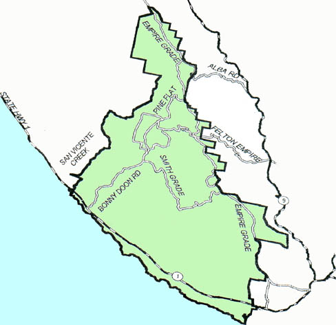 If you live in or own property within this district, roughly
from Empire
Grade to the ocean and from San Vicente Creek to the City of Santa Cruz
border, you are eligible to be an RBDA member. Please support the RBDA!
Dues payments count for a full year from date received. Dues mostly go for printing and mailing The Highlander, your voice for keeping Bonny Doon rural and natural. Click here for details! Those who make additional contributions qualify as: CONTRIBUTORS ($ 25+ dues) SUSTAINERS ($50+ dues), or PATRONS ($ 100+ dues)
|